提案内容/Competition Details
震災以前、震災以降
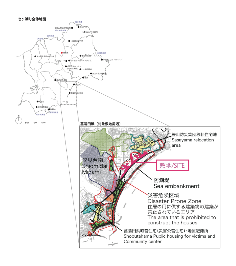
敷地が位置する七ヶ浜町は、人口約2万人の最も小さい被災自治体であり、仙台から北東に車で40分ほど、松島湾の南西に位置する半島状の丘陵地を町域としている。三方を海に囲まれているため、東日本大震災で発生した津波により大きな被害を受けた。敷地のある菖蒲田浜地区は、比較的平坦な地域で南に開けた長い海岸線を持ち、海辺に集落が広がっていたため、町の中でも最も大きな被害を受けた地域である。歴史をひもとくと、現在の位置に移転するまで、73年間町役場が置かれており、行政の中心であるとともに、東北地方で始めての海水浴場が開かれ、震災以前は年間5万人の海水浴客が訪れるというにぎわいの中心でもあったが、震災以後は遊泳禁止となっている。また、七ヶ浜町では沿岸漁業に加えて、海苔養殖、アワビ養殖が行われており、菖蒲田浜でも震災前は100名ほどが従事していたが、震災後は40名程度に落ち込んでいる。
復興の方針
復興計画において、敷地は現在、災害危険区域として住宅用途の建築物の建設が禁止されている。そのため低平地に住んでいた人たちの再建場所として、町では海岸の南側の内陸に公営住宅、海岸の北側の高台(笹山地区)に宅地の整備を行った。昨今入居も完了し新たな場所で新しい生活をスタートさせている。また、浜辺では、次第に仙台近郊からのサーファーや釣り人なども戻りつつあり、少しずつは活気を取り戻しつつあるが、海ー低平地ー住宅地の関係性は分断されているのが現状である。
残された低平地のボイドは現在、観光用地としての活用が計画されているが、居住禁止区域とするにあたって所有者から土地を買い上げたため、不整形の土地が連続する敷地となっており、町としても具体的な活用方法を決めかねている。
浜のポテンシャル
提案においては、防潮堤というinhumanなスケールに対して、いかにしてhumanなスケールでもって向き合うべきかという問いについても、提案内の重要な要素として答えてもらいたい。また、現地は災害危険区域として住宅用途の建築物の建設が現在禁止されている。しかし、アジアの被災地域の中では防潮性を持つように建築の性能に対してレギュレーションを課すことで、用途地域内での建築用途の可能性を広げる実例もすでに存在している。このように、建築自体の性能を問い直すことで、被災した土地の可能性を引き出すような提案も期待したい。
問題と解決
本設計競技では、東日本大震災の被害にあった宮城県七ヶ浜町菖蒲田浜地区に下記にある3つの検討すべきテーマを切り口に、これまでの菖蒲田浜の歴史やこの土地の可能性を活かした観光用地としてどのようなゾーニングをすべきか敷地全体のマスタープランを計画した上で、その要となる具体的な建築や空間の提案を求める。建築提案において設定するプログラムは自由とするが、下記のテーマのうち最低1つを反映したものとする。
① かつてそこにあった人々の漁業や海苔の養殖をベースとした『生業の復活と新たな産業』
(例:海苔工場やその生産過程の産業の体験施設、道の駅のような複合施設など)
② 菖蒲田浜地区のかつてあった『まちの拠点・賑わい』
(例:公園やランドスケープの提案、防潮堤を越えて連続する橋のような提案など)
③ 仙台近郊からのサーフィンやフィッシングなどの『観光資源としての浜』
(例:海の家、サーフビレッジなど観光スポットともなる施設など)
敷地は敷地概要に示した地図上ピンクの部分とする。町ではこの部分を観光用地として設定している。
ただし、必要であれば周囲の敷地も含めて提案してほしい。
Before and After 3.11
The town of Shichigahama where the site is located, has the total population of approx. 20,000, and it is the smallest municipality of all towns affected by the disaster. It is situated at 40min-drive distance north-east of Sendai, on a small hilly peninsula, south-west side of Matsushima-bay. Due to its geographical feature of being surrounded by the sea on its three sides, the area was greatly damaged by the tsunami caused by the Great East Japan Earthquake. The Shobuda-hama district where the site is, was a fairly flat area with long open shoreline to the South, and since the settlements were mostly spreading along the seashore, the tsunami damage was the greatest within the town of Shichigahama. Historically, the area used to be the center of the town's governance with its town hall stood for 73 years until its re-location. The area's beach holds historical value of being the first public swimming beach to be opened in the entire North-East region of Japan, and it used to have 50 thousand visitors per year prior to the disaster, but no swimming is allowed after the tsunami. Also, the town of Shichi-ga-hama used to be flourished with coastal fishery as well as the sea-weed and abalone cultivation, and even within small district of Shobuda-hama, there were about 100 people engaged in them, but now after the tsunami, there are only about 40 of them left.
Reconstruction Plan
Under the reconstruction master plan, the Shobuda-hama site is currently designated as the disaster prone area, being prohibited from building any residential buildings. Due to this reason, the town has chosen two main areas for relocation of the people who used to live in the flat low land; the inland social housing blocks at the south, and the high-ground housing neighborhood at the north, Sasayaa area. Now there are families moving in and starting their new lives in those new residential areas. At the beach, some fishermen and surfers are gradually returning and the area is regaining its livelihood little by little, but the disconnection between the sea, the flatland and the residential still remains.
Potentials
In your proposal, please address the issue of how to face the inhuman-scale tide embankment with the human-scale, as an important point of the proposal. Also, although the site area is being prohibited from constructing any residential buildings, there are various precedents in Asia, where the land-use regulations within the prohibited area was mitigated by requiring a certain level of the architectural performance such as resistance to the tide. We hope that the proposals can bring about the future potentials of the damaged site through re-evaluation and invention of the architectural performance as well.
Problems and Solutions
The flatland or the void is currently being planned to be as the site for the tourism area. In this competition, please propose an alternative master-plan of the area, taking into consideration of the three key themes listed below, reflecting on the history of the Shobuda-hama area and its future potentials. Also please propose a specific architectural design or space design that will play a major role within your overall master-plan. For this part, the program of the building and/or space is open, but please reflect at least one of the 3 key themes.
① Consider the fishery and sea-weed cultivation once flourished on the site and think of the ways to"revive the local trade and introduce the new industries."
(ex. Sea-weed/Sea-food processing factories and other public experiential facilities, Multi-functional complex like the road-side service/market area etc)
② As it used to be the city center, design "the new node for the city with full of activities."
(ex. Park and Landscape, Bridge-like element connecting over the embankment etc)
③ "Develop the seashore as a tourism resource" especially targeting the surfers and fishers from the outskirts of Sendai city.
(Facility that would become a tourism destination such as the beachside clubhouses or surf village etc)
Although the set site area indicated in Pink on the map, is where the town is considering for future tourism development zone,
if necessary, the areas beyond the pink zone can also be considered as part of your proposal.
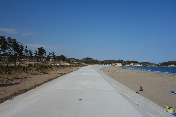
敷地状況/Site Photos
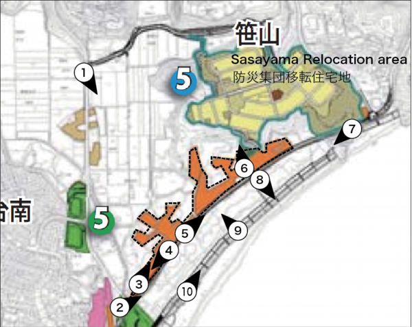
Photo1 内陸の農地から海岸方向
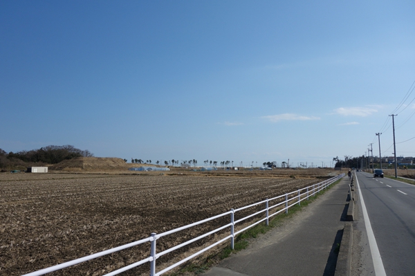
Photo2 敷地南端から北東側
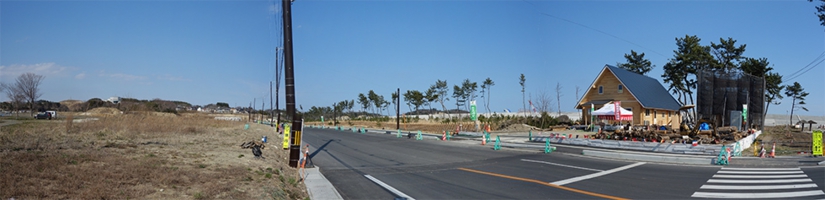
Photo3 敷地南端から北側
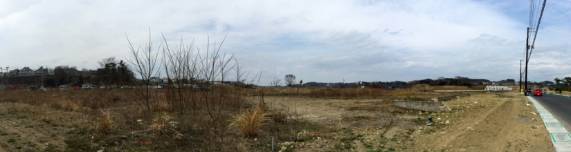
Photo4 敷地から汐見台団地
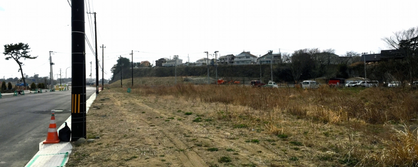
Photo5 敷地中心あたりから北東側
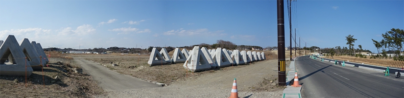
Photo6 敷地から笹山防災集団移転住宅地
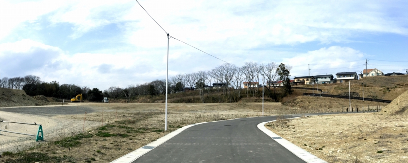
Photo7 敷地北端から南西側
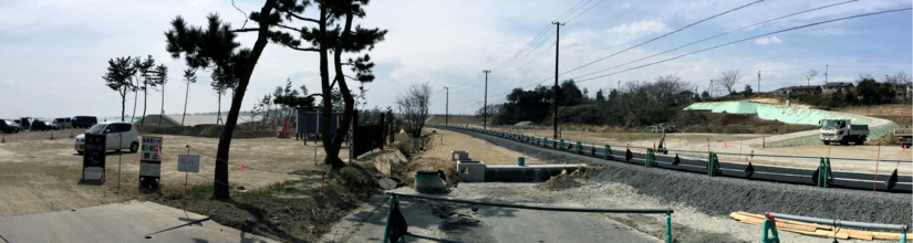
Photo8 防潮堤北面
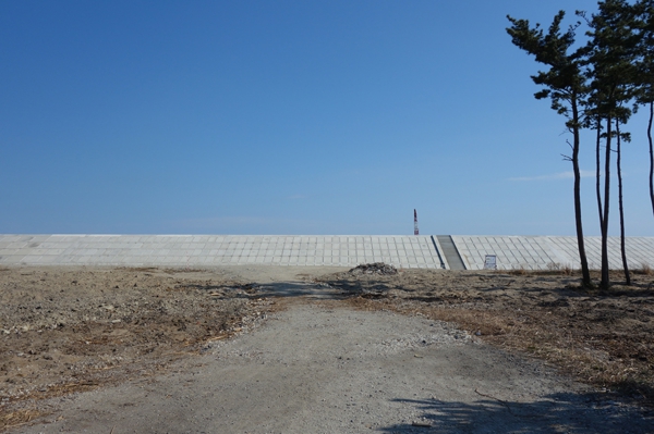
Photo9 防潮堤から敷地全体
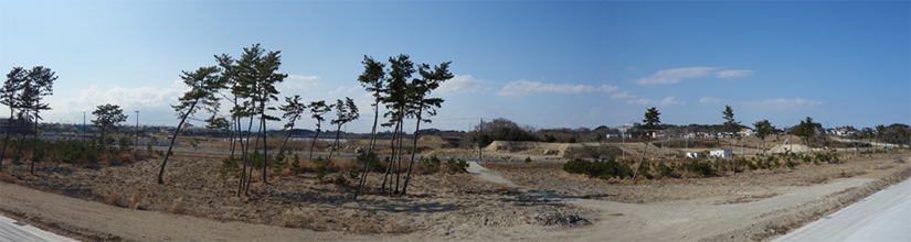
Photo10 防潮堤から北東側